Puerto Princesa is a highly urbanized city on the shore of Puerto Princesa Bay, midway along Palawan's mainland, and the main gateway to the province. With 2,381 km² of land it is the largest city in Palawan and in MIMAROPA, and one of the largest in the country by area.
City of 66 barangays, 2,381.02 km² of land.
Puerto Princesa is a highly urbanized city on the shore of Puerto Princesa Bay, midway along Palawan's mainland, and the main gateway to the province. With 2,381 km² of land it is the largest city in Palawan and in MIMAROPA, and one of the largest in the country by area.
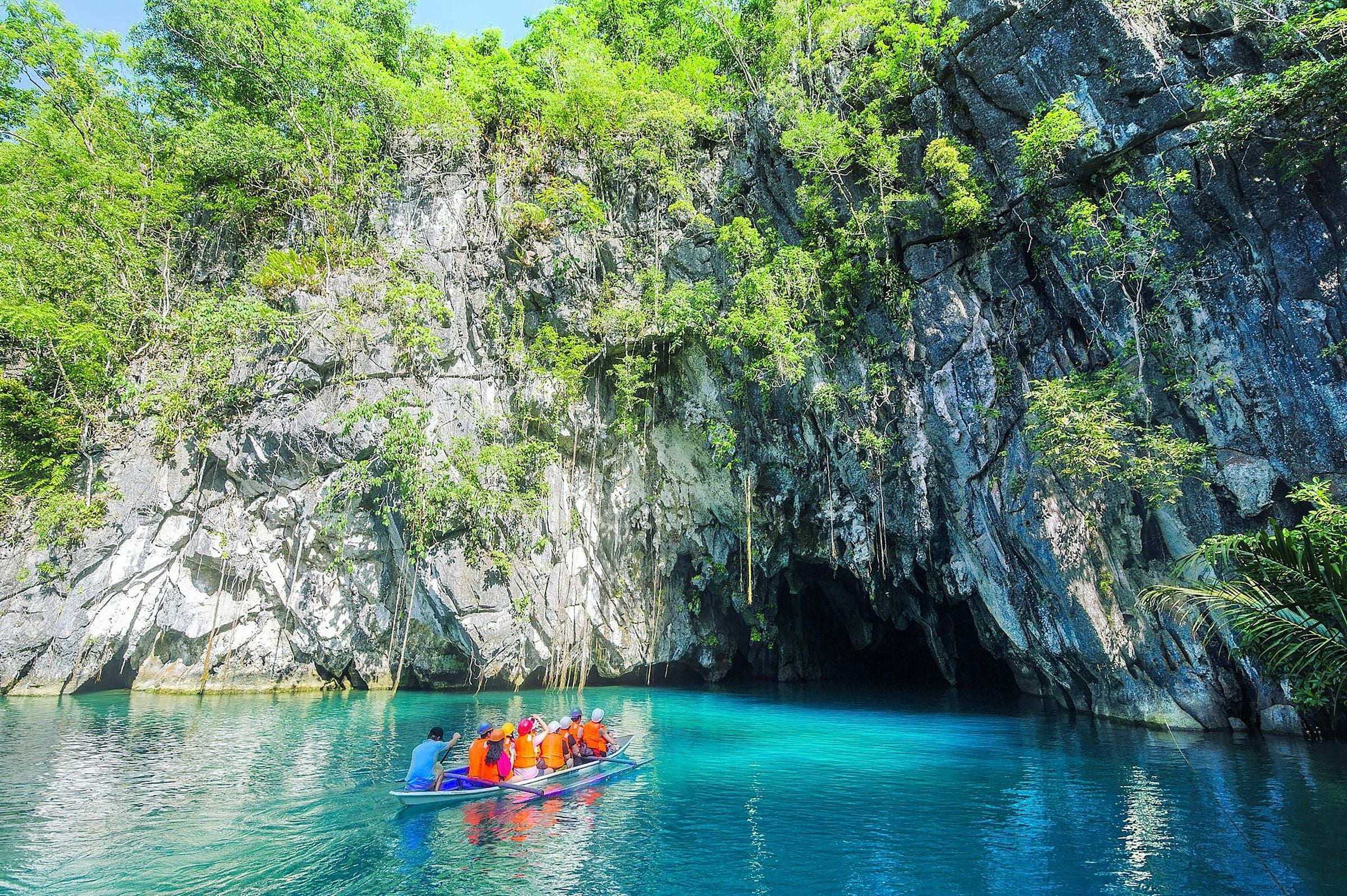
About three quarters of its people live in the city proper by the bay. The rest of its 66 barangays reach across the island to the West Philippine Sea coast, where the Puerto-Princesa Subterranean River National Park, a UNESCO World Heritage Site, protects a limestone karst landscape whose underground river flows straight into the sea.
Around Puerto Princesa
Puerto Princesa marks its founding anniversary with the Balayong Festival on 4 March, named for the balayong, or Palawan cherry, tree.
Puerto Princesa's nicknames include 'The City in the Forest' and 'Eco-Tourism Center of the Philippines'.
Island
Honda Bay
Bay on the city's mid-eastern coast, north of the city proper; its islands include Cowrie, Bat, Arrecife and Isla Pandan, with snorkelling at Pambato Reef.
Heritage
Plaza Cuartel
National Historical Site: the restored ruin of an old garrison where Japanese soldiers burned about 150 American prisoners of war on 14 December 1944.
Heritage
Iwahig Prison and Penal Farm
Penal farm set up by the Americans in 1904 and called a 'prison without bars'; inmates tend farms instead of spending time behind bars.
Mountain
Ugong Rock
Rock in Barangay Tagabinet, a community-based tourism site; visitors climb to the summit for views of karst mountains and paddy fields, then zipline down.
Nature
Crocodile Farm and Nature Park
Facility on South Road, Barangay Irawan, conserving the saltwater and endemic Philippine freshwater crocodiles, with a nature park sheltering Palawan wildlife.
Heritage
Immaculate Conception Cathedral
Neo-Gothic Catholic cathedral near the Port of Puerto Princesa; the present structure took almost a century to build and was completed in 1961.
A short history
Spanish colonists founded the settlement as Puerto de la Princesa on 4 March 1872, and the bay soon became the centre of Spanish naval operations in the region. The town became a city on 1 January 1970.
The city tourism office describes Puerto Princesa as a meeting place of many cultures. Cuyonon families are among the oldest residents and Cuyonon is still the main local language, while the Tagbanua and Batak are among the indigenous peoples of the city's uplands and coasts.
The way in
Manila
From Manila: Flights from Manila to Puerto Princesa International Airport take about 1 hour 15 minutes, with daily services; there are also flights from Cebu, Davao, Iloilo and Clark. By sea, 2GO sails weekly from Manila, a trip of about 32 hours.
Puerto Princesa
Nearest gateway. Puerto Princesa International Airport (PPS), in the city proper; Puerto Princesa port
10°12′N 118°55′E
Puerto Princesa Subterranean River National Park
Heritage, Mountains and waterfalls
How to get there. By van from Puerto Princesa city (about 80 km, two hours) to Sabang wharf, then a short boat ride along the coast to the cave entrance
Best time. November to May, dry season, when river levels and seas are calmer
Before you go
Fees, rules and schedules change. Check them with the town.
- Official website
- City Government of Puerto Princesa
- Tourism office
- City Tourism of Puerto Princesa
- Facebook page
- City Government of Puerto Princesa on Facebook
- Facebook page
- Puerto Princesa City Tourism on Facebook
- Local government
- City of Puerto Princesa
- Sources
Sources (14)
- PSGC code 1731500000 and 66 barangaysPSGC API, data from the PSA Philippine Standard Geographic Code (psgc.gitlab.io; release not stated by the mirror, counts cross-checked with psgc.cloud and PhilAtlas)
- Land area 2381.02 km² (PSA 2013 figure) and barangay countPuerto Princesa Profile, PhilAtlas
- Highly urbanized city; largest city in Palawan and MIMAROPA by area; founded 4 March 1872 as Puerto de la Princesa; naval centre from May 1872; city from 1 January 1970; three quarters of residents in the city proper on Puerto Princesa Bay; airport in the city properPuerto Princesa, Wikipedia
- Flight times from Manila, Cebu and Davao, flights from Iloilo and Clark; weekly 2GO ferry from Manila, about 32 hoursGetting to Puerto Princesa, City Tourism of Puerto Princesa
- Cuyonon among the original inhabitants and the predominant local tongue; Tagbanua and Batak indigenous groupsPeople and Culture, City Tourism of Puerto Princesa
- Underground river emerging directly into the sea in a limestone karst landscape; World Heritage SitePuerto-Princesa Subterranean River National Park, UNESCO World Heritage Centre
- Puerto Princesa marks its founding anniversary with the Balayong Festival on 4 March, named for the balayong, or Palawan cherry, tree.March 4 - Balayong Festival - Puerto Princesa City Tourism
- Puerto Princesa's nicknames include 'The City in the Forest' and 'Eco-Tourism Center of the Philippines'.Puerto Princesa - Wikipedia
- Honda BayHonda Bay Tour - Puerto Princesa City Tourism
- Plaza CuartelHistorical Landmarks - Puerto Princesa City Tourism
- Iwahig Prison and Penal FarmHistorical Landmarks - Puerto Princesa City Tourism
- Ugong RockCBST Destinations - Puerto Princesa City Tourism
- Crocodile Farm and Nature ParkCrocodile Farm and Nature Park - Puerto Princesa City Tourism
- Immaculate Conception CathedralImmaculate Conception Cathedral (Puerto Princesa) - Wikipedia